Mount Rainier
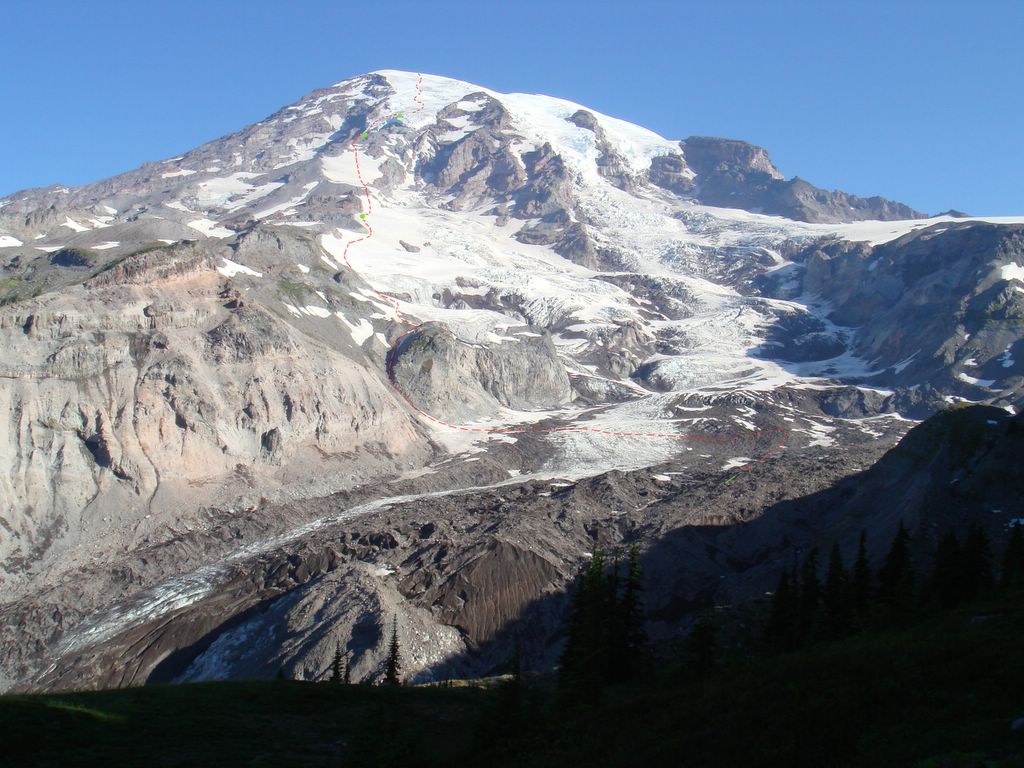
Mount Rainier is a volcano in the Cascade Mountains. It is the tallest mountain in Washington State at 14,411 ft., and the 5th tallest in the continental United States. According to the National Parks Service, last year nearly 9,000 attempted to climb Mt. Rainier. Just over half of them were successful. Only 276 of them attempted the route we chose: the Kautz Glacier.
To start the route, Joe, Matt, Mike and I began at 5,400 ft. where the NPS has a very nice visitor center. We started hiking around 7 AM on Monday, the 14th. We hiked through some beautiful alpine meadows with an amazing amount of wildfowers in bloom. We hiked until with met the Nisqually Glacier, where we put on our crampons, roped up, and crossed. After crossing the glacier, we ascended a rockfall gully called "The Fan." We had some lunch before heading out onto the Wilson Glacier and up to our first campsite.
The first night we set up our camp on the edge of the Wilson Glacier at about 8,200 ft. When we awoke the next morning we had an awesome view with the clouds a few thousand feet below us. We started out around 7 AM again and went the rest of the way up the glacier. We reached a rock band where we unroped and climbed up to "The Turtle," which is a large, steep snowfield. We spent the rest of the day ascending this and set up camp at around 11,200 ft.
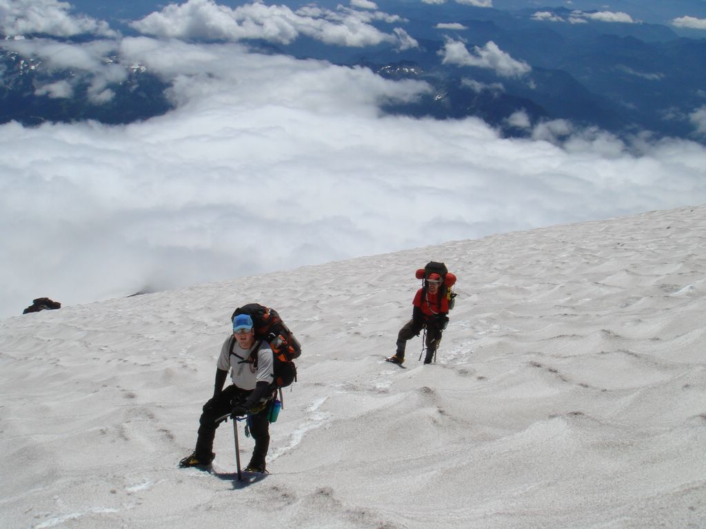
The following morning we got an "alpine start," meaning that we awoke at 2 AM and started off by 3AM when the snow was still very cold and hard, making ice and rockfall less likely. The cold conditions at this time also make snowbridges more stable and allows for quicker travel. The first obstacle we had to overcome was a 30 to 40 foot cliff that needed to be descended. We rappeled down this and then continued on through an icefall area to some technical ice climbing sections on the Kautz Glacier. There was far more vertical ice than we had expected, and we ended up behind schedule.
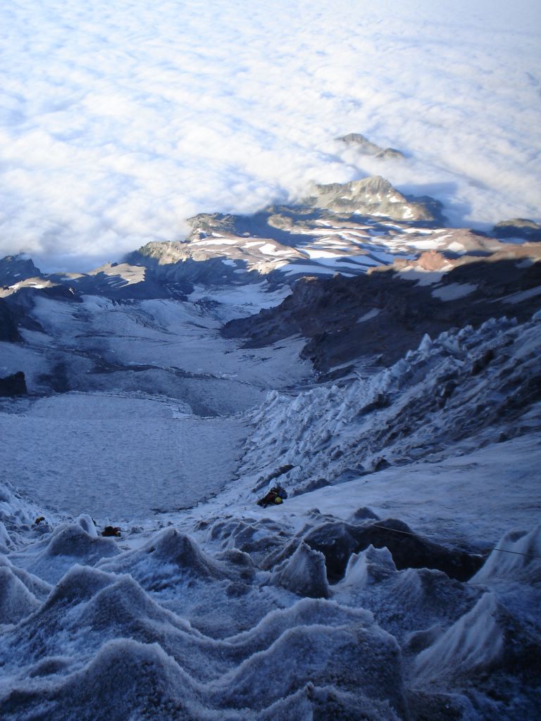
Once we topped-out on the ice, we still had some glacier travel to go. By this time the sun had some out and we were slowed down by hidden crevasses. We ended up finding a suitable campsite at around 13,000 ft. after 9 hours of climbing and glacier navigation. We ate some dinner and went to bed around 6 PM that evening to get enough rest for another alpine start the next morning.
The fourth day on the mountain was summit day. We spent about 3 and 1/2 hours navigating more crevasses before making it to the summit at 6:30 AM. We spent the rest of the day descdending the 9000 feet we'd climbed. By the end of the day we were all beat. We headed back to Tacoma and had some beer and pizza as a reward and crashed out for the night.
I had a great time on this trip and was treated to some awesome views. The sights were absolutely amazing. "Thank you" to Mike, Matt, and Joe. I can't wait for the next one...
To start the route, Joe, Matt, Mike and I began at 5,400 ft. where the NPS has a very nice visitor center. We started hiking around 7 AM on Monday, the 14th. We hiked through some beautiful alpine meadows with an amazing amount of wildfowers in bloom. We hiked until with met the Nisqually Glacier, where we put on our crampons, roped up, and crossed. After crossing the glacier, we ascended a rockfall gully called "The Fan." We had some lunch before heading out onto the Wilson Glacier and up to our first campsite.
The first night we set up our camp on the edge of the Wilson Glacier at about 8,200 ft. When we awoke the next morning we had an awesome view with the clouds a few thousand feet below us. We started out around 7 AM again and went the rest of the way up the glacier. We reached a rock band where we unroped and climbed up to "The Turtle," which is a large, steep snowfield. We spent the rest of the day ascending this and set up camp at around 11,200 ft.
The following morning we got an "alpine start," meaning that we awoke at 2 AM and started off by 3AM when the snow was still very cold and hard, making ice and rockfall less likely. The cold conditions at this time also make snowbridges more stable and allows for quicker travel. The first obstacle we had to overcome was a 30 to 40 foot cliff that needed to be descended. We rappeled down this and then continued on through an icefall area to some technical ice climbing sections on the Kautz Glacier. There was far more vertical ice than we had expected, and we ended up behind schedule.
Once we topped-out on the ice, we still had some glacier travel to go. By this time the sun had some out and we were slowed down by hidden crevasses. We ended up finding a suitable campsite at around 13,000 ft. after 9 hours of climbing and glacier navigation. We ate some dinner and went to bed around 6 PM that evening to get enough rest for another alpine start the next morning.
The fourth day on the mountain was summit day. We spent about 3 and 1/2 hours navigating more crevasses before making it to the summit at 6:30 AM. We spent the rest of the day descdending the 9000 feet we'd climbed. By the end of the day we were all beat. We headed back to Tacoma and had some beer and pizza as a reward and crashed out for the night.
I had a great time on this trip and was treated to some awesome views. The sights were absolutely amazing. "Thank you" to Mike, Matt, and Joe. I can't wait for the next one...
posted by Chris | 12:34 PM
|
4 comments
![]()